My AI agents found an unmapped Maya site?
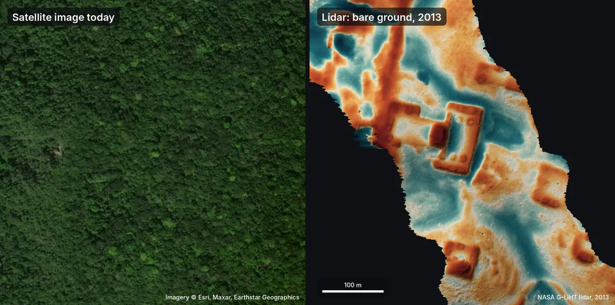
Pietro Miotti, who writes at pietromiotti.com, says he asked 48 AI agents to search public NASA lidar data for Maya ruins. According to Fathom, NASA's free lidar archive did not cover Peru, so he turned to the Maya region. Lidar measures the ground beneath forest canopy, so man-made mounds appear as shapes in the elevation data. Per Adafruit's summary of the post, the agents converted about 1,200 square kilometres of lidar strips into images and reviewed them one by one, flagging pyramids, platforms and plazas while setting aside natural hills, sinkholes and roads. No specialist model was used. The agents worked from a written guide and checked the raw point cloud to confirm that shapes sat on the ground rather than in the canopy.
The agents drafted a report in Spanish, and Miotti sent it to INAH, Mexico's National Institute of Anthropology and History. INAH replied in under 72 hours that its records held no registered archaeological site at the location. Fathom describes the flagged hilltop as having a levelled plaza, an oval pyramid of roughly 8 to 12 metres, a raised courtyard and a hollow that may be a reservoir. On 11 November, Miotti updated the post to say the site had already been mapped in a 2025 paper by Estrada-Belli and colleagues, which the agents missed. He now calls it a rediscovery, and he labels his guesses about the site's period and purpose as speculation.
Why it matters
For founders, the episode shows that general-purpose agents can run a first-pass screen over large public remote-sensing datasets and produce a formal report for a government body in about three days, without a custom model. That lowers the cost of some research and monitoring workflows and puts pressure on startups whose pitch rests on a bespoke classifier.
The case also shows where these systems fail. The agents missed a published paper during their literature review, and the absence of a register entry did not show that nobody knew about the site. Operators and investors should expect buyers in public agencies and regulated fields to ask for provenance, literature checks and verification before accepting agent-generated findings.
Key points
- 1The agents covered about 1,200 square kilometres of NASA lidar strips, converted into images and reviewed one by one.
- 2The agents worked from a written guide, with no specialist archaeology model, according to the author's account.
- 3INAH replied within about 72 hours that its records showed no registered archaeological site at the reported location.
- 4The author's November 11 update says the site had already been mapped in a 2025 paper by Estrada-Belli and colleagues.
- 5No field check has taken place, and any ground survey would need INAH approval, according to one report.